RESIDENTIAL, COMMERCIAL & OUTDOOR SPACES
3D Scanning & Measured Floor Plans
Clearer information for buying, selling and planning your next project.
RENOVA8 provides laser scanning for buildings, outbuildings and external spaces across Bordeaux, Gironde and Charente.
Choose 2D dimensioned schematics, 3D dimensioned schematics, a 3D virtual tour, or a combination tailored to your requirements.
Understand an existing property, make remote viewing easier and give contractors better information for preparing quotations—from an individual room to a complete building and its surrounding grounds.
UNDERSTANDING THE SERVICE
Capture the Property as It Is Today
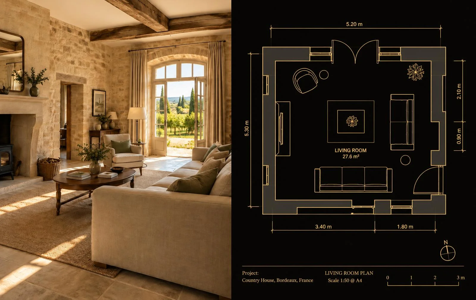
Original plans are often missing, incomplete or no longer reflect the property. Photographs alone may not explain the layout, dimensions or relationship between different spaces.
A 3D laser survey captures the geometry of visible surfaces and creates a digital record of the surveyed areas. We use that information to prepare your selected drawings and virtual-tour outputs.
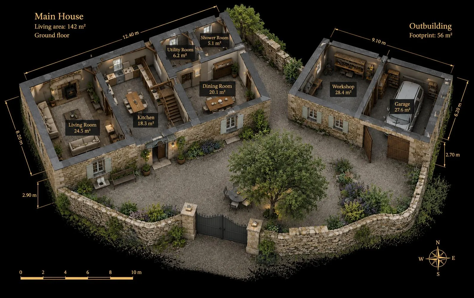
The survey can include interiors, building exteriors, outbuildings, courtyards, gardens and landscapes. Coverage is agreed according to your requirements, access and site conditions.
Whether you are assessing a purchase, presenting a property for sale or preparing work for contractors to price, the result is a clearer reference for your next decision.
TAILORED TO YOUR REQUIREMENTS
One Survey. Your Choice of Deliverables.
We start with what you need to achieve.
You may want dimensioned plans of a house without existing drawings, a 3D representation of a complex building, a virtual tour for prospective buyers or a shared reference for contractors bidding for work.
We agree the survey coverage, selected deliverables and required detail before the visit. Scanning, processing and preparation of your agreed outputs are handled in-house, giving you one point of contact throughout.
Who We Work With
- Homeowners: document existing spaces and prepare for improvements.
- Sellers and estate agents: help prospective buyers understand and explore a property.
- Buyers and investors: assess layouts and dimensions before developing proposals.
- Commercial owners and occupiers: record premises for letting, refurbishment or space planning.
- Contractors: review existing spaces and prepare more informed quotations.
- Architects, designers and property managers: obtain an existing-property reference for their work.
The service can be commissioned independently of RENOVA8’s renovation project management.
DELIVERABLES & SURVEY COVERAGE
Choose What to Capture and How to View It
Select your deliverables individually or combine them. The survey can cover the buildings and outdoor areas relevant to your project.
2D Dimensioned Schematics
Clear measured drawings showing the surveyed layout, dimensions and agreed annotations. A practical reference for understanding spaces, presenting a property and briefing contractors or designers.
3D Dimensioned Schematics
Understand the surveyed property in three dimensions. Measured representations help explain its form, proportions and the relationship between spaces.
3D Virtual Tours
Explore the captured property remotely through an interactive virtual tour. Help prospective buyers, contractors and project teams revisit the space without travelling to site each time.
Residential & Commercial Buildings
Scanning for homes, apartments, offices, shops, hospitality premises and other buildings. The scope can cover selected areas or the complete accessible building.
Outbuildings & Additional Structures
Include barns, garages, workshops, guest accommodation, storage buildings and other structures to document the wider property.
Exteriors, Gardens & Landscapes
Capture accessible building exteriors, courtyards, gardens and landscape features where required. Outdoor coverage is agreed according to access, visibility and site conditions.
Choose one or more deliverables to suit your project. Your quotation confirms the survey coverage, drawing detail, file formats, delivery programme and any virtual-tour hosting arrangements.
WHY IT MATTERS
Better Visibility. Clearer Quotations. More Informed Decisions.
Make Property Viewing Easier
Help prospective buyers explore a property remotely and understand its layout before arranging a visit. A virtual tour is particularly useful for buyers travelling from another region or country.
Help Contractors Assess the Work
Give contractors bidding for your project a clearer understanding of the existing building. Dimensioned schematics and virtual viewing help them assess spaces, review access and prepare questions before visiting.
Support More Accurate Quantities and Pricing
Measured information makes it easier to calculate relevant lengths, areas and quantities within the surveyed scope. This supports more detailed quotations and reduces reliance on assumptions, with project-critical measurements verified where required.
Save Time and Reduce Avoidable Costs
Revisit the captured property information remotely. This can reduce repeated measurement visits, unnecessary travel and time spent clarifying dimensions or explaining the layout.
Compare Contractor Proposals More Clearly
Give competing contractors the same existing-property information. Combined with a consistent scope of works, this helps you compare quotations and identify differences in quantities, allowances and exclusions.
Keep Everyone Working from the Same Information
Share a clear visual and dimensional reference with buyers, agents, designers and contractors. A common understanding of the property helps reduce misunderstandings and supports more efficient planning.
HOW IT WORKS
From Site Capture to Finished Deliverables
01
Define Your Requirements
Tell us about the property, the areas to include and how you intend to use the results.
02
Agree Your Package
Choose your deliverables. We confirm the scope, required detail, price and delivery programme.
03
Scan the Property
We capture the agreed accessible interiors and external areas, recording any restrictions or obscured features.
04
Process & Prepare
We process the survey data, prepare your selected outputs and review them against the captured information.
05
Deliver & Explain
You receive the agreed files and viewing access, with an explanation of the deliverables and any relevant limitations.
YOUR QUESTIONS
Frequently Asked Questions
Get a Clearer Picture of Your Property
Whether you need plans for a sale, information for a purchase or measured references for contractors, RENOVA8 can tailor the survey to your project.
Serving Bordeaux, Gironde and Charente. Other locations considered according to the project.
English and French spoken.